
Cleaning a Track
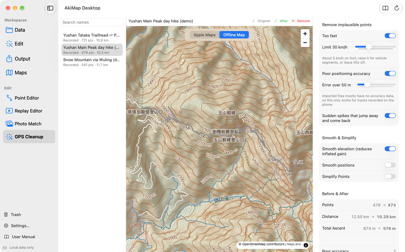
- Choose Edit ▸ GPS Cleanup and pick a track.
- Turn on the cleanup options you want in the right panel (see the table).
- The map shows the original in gray, the cleaned track in green, and removed points in red; the legend above the map explains the colors.
- Compare points, distance and total ascent under “Before & After”.
- Click “Save as New Item”, or “Overwrite Original Points…”.
| Option | What it does |
|---|---|
| Too fast | Removes points that would need more than the limit (30 km/h by default) to reach. Needs timestamps. Walking is about 5 km/h; raise the limit for trips with a ride, or leave it off. |
| Poor positioning accuracy | Removes points whose reported error exceeds the limit (50 m by default). Imported files mostly have no accuracy data, so this works for phone-recorded tracks. |
| Sudden spikes that jump away and come back | Removes points that briefly jump off the route and return at once. |
| Smooth elevation | Reduces elevation noise so total ascent is not inflated. |
| Smooth positions | Smooths latitude and longitude with a moving average; the window size is adjustable. |
| Simplify Points | Drops redundant points within a tolerance to make the file smaller. |
Too fast
What it does:Removes points that would need more than the limit (30 km/h by default) to reach. Needs timestamps. Walking is about 5 km/h; raise the limit for trips with a ride, or leave it off.
Poor positioning accuracy
What it does:Removes points whose reported error exceeds the limit (50 m by default). Imported files mostly have no accuracy data, so this works for phone-recorded tracks.
Sudden spikes that jump away and come back
What it does:Removes points that briefly jump off the route and return at once.
Smooth elevation
What it does:Reduces elevation noise so total ascent is not inflated.
Smooth positions
What it does:Smooths latitude and longitude with a moving average; the window size is adjustable.
Simplify Points
What it does:Drops redundant points within a tolerance to make the file smaller.
Screens may vary by app version. See Support and FAQ if you need help. Support